- News Releases
- SKY Perfect JSAT Corporation
- Space Business
- SKY Perfect JSAT and ITOCHU Announced Commencement of SAR Satellite-Based Oil Spill Monitoring Service to Qatar
News Releases
SKY Perfect JSAT and ITOCHU Announced Commencement of
SAR Satellite-Based Oil Spill Monitoring Service to Qatar
Jun 19, 2023
SKY Perfect JSAT Corporation (Headquartered: Minato-ku, Tokyo; Representative Director, President & Chief Executive Officer: Eiichi Yonekura; hereinafter "SKY Perfect JSAT") and ITOCHU Corporation (Headquarters: Minato-ku, Tokyo; President and COO: Keita Ishii; hereinafter “ITOCHU”) announced today the commencement of Synthetic Aperture Radar (SAR*1) satellite-based oil spill detection service to the Qatari Ministry of Environment & Climate Change (hereinafter “Qatari MECC”).
Around the world, about 2,000 oil spill accidents caused by oil tankers have been reported since the 1970s*2. Especially in the Persian Gulf coast including Qatar, where many multi-national vessels navigate, countermeasures for oil leak have been studied for many years. From perspective of environmental protection, it is important to detect and deal with such oil leak from a vessel as early as possible before it reaches the shore.
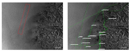
This service is provided in joint partnership with Kongsberg Satellite Services, AS (Headquartered: Tromsø, Norway, hereinafter “KSAT”), a leading provider of global ground network and satellite-based earth observation services and uses SAR satellite imagery downlinked at KSAT and its partners' ground stations to detect offshore oil leaks. Following such process, analysis is performed in combination with AIS (Automatic Identification System) information*3 transmitted from vessels, and the vessel with the oil leak can be identified.
As result of joint proposal activities to the Qatari MECC by SKY Perfect JSAT and ITOCHU, service features such as capability to observe wide sea area by using combinations of various satellites and provision of daily and emergency observation reports were evaluated by the Qatari MECC and led to this service commencement. This is the first case in which the two companies jointly provide satellite data-based analysis service overseas. In addition to continuously providing this service to Qatar, we plan to expand this service to other countries and companies in sea areas where there is similar demand, protecting the marine environment and preventing damage at important facilities such as desalination facilities and power plants in coastal areas from oil leaks.
SKY Perfect JSAT and ITOCHU will continue to pursue the enhancement of corporate value by contributing to the sustainability of society and the environment, solving social issues through business activities and aiming for sustainable growth.
*1 SAR: Synthetic Aperture Radar. A radar that obtains an image of the earth surface by irradiating the ground surface with microwaves and analyzing the signals that are reflected back. It is characterized by being able to penetrate clouds and volcanic smoke, and to observe the situation of the ground surface regardless of day or night or weather.
*2 Quoted from International Tanker Owners Pollution Federation.
*3 AIS information: Information such as vessel’s identification code, name, location, speed, course, destination, etc., transmitted from its Automatic Identification System. From perspective of maritime safety, such as collision prevention, vessels navigating the sea are obliged to exchange such voyage related information with each other, and to be installed on certain vessels as stipulated by the SOLAS Convention (Convention for the Safety of Life at Sea). The purposes are (1) to identify vessels, (2) to assist in tracking targets, (3) to facilitate the exchange of voyage information, (4) to provide information useful in collision avoidance, (5) to reduce ship reports by radiotelephone. For this reason, the AIS device must always be turned on, even when the vessel is anchored, and continuing to transmit the vessel's own information so its location can be determined at all times.
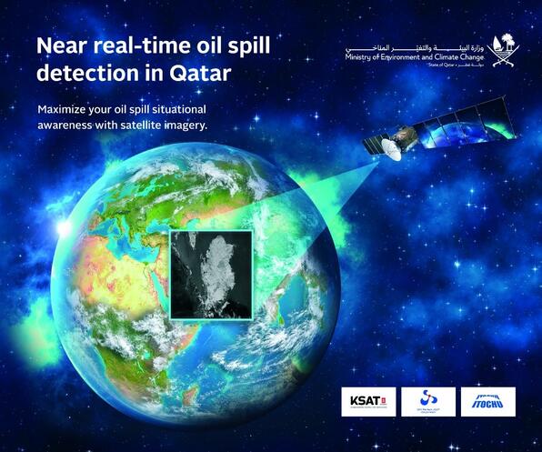
Figure 1. Key Visual of SAR Satellite-Based Oil Spill Monitoring Service
Figure 2. (Left) Satellite imagery of oil leak detected in red
(Right) Satellite imagery with AIS data shows vessels’ routes in green to detect source of oil leak
■Related Links
●December 7, 2016, SKY Perfect JSAT Release
SKY Perfect JSAT has entered into a Strategic Alliance with Kongsberg Satellite Services to accelerate LEO-related businesses and enter into marine information service
https://www.skyperfectjsat.space/en/news/files/pdf/news_sjh_en_20161207_01.pdf
●SKY Perfect JSAT Space Business Website
https://www.skyperfectjsat.space/jsat/en/

